Overcrowding and population density are by definition two crucial factors in the subject of pandemic risk. In a hyper-connected global world, inhabited by 7.5 billion people, 55% of whom are concentrated in urban areas (70% in 2050), emergency health risk situations are growing at an increasingly high rate.
Social distancing is the most effective measure to prevent and contain the spread of pandemics. The restrictions we are experiencing today may therefore become a continuous part of our lives and the way we inhabit and plan our cities in the future.
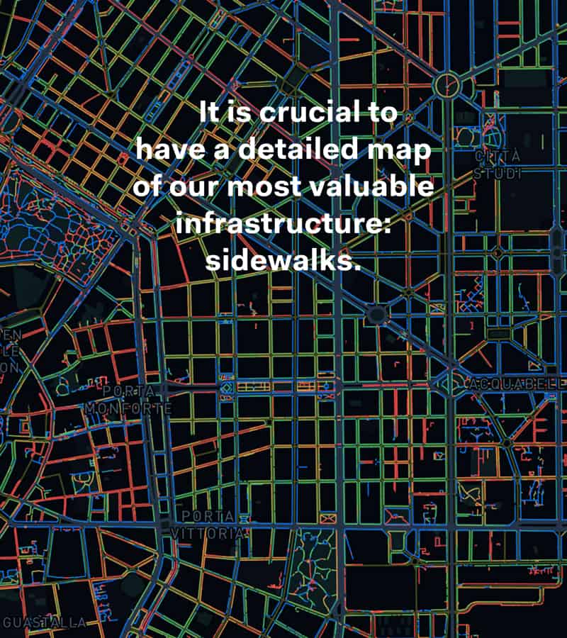
Systematica took up this challenge by applying a methodology on Milan, replicable in any urban center, for the mapping and the consequent adaptation of pedestrian infrastructures (sidewalks) in order to guarantee the fulfilment of the requirements of social distancing.
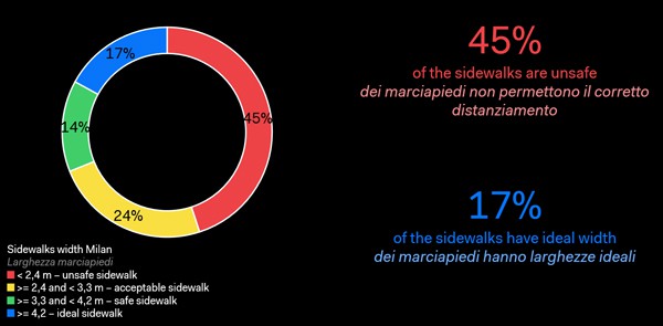
The preliminary results, that necessarily need to be verified in a later stage by a much more detailed data collection, is that more than 40% of Milan’ sidewalks is not adequate to allow the necessary social distancing measures.
It is therefore required, in line with the principles and objectives of “open street” plan currently being promoted by Milan Municipality, a capillary and diffuse series of interventions is required to retrofit our sidewalks and grant adequate comfort and safety levels for pedestrians.
Benefits for the municipality
Mapping the pedestrian infrastructure inevitably brings significant advantages to multiple actors. First, administrations will gain a number of benefits, including:
- Bolster the capacity to analyze and plan pedestrian spaces
- Verify the suitability of pedestrian infrastructures with respect to the rules of social distancing
- Prioritize and define the type of interventions based on the existing situation
- Quickly adapt infrastructure to emerging needs
Once shared, mapping can be a fundamental decision-making tool also for planners and citizens.
Methodology
Social distancing and sidewalks
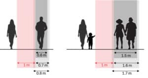
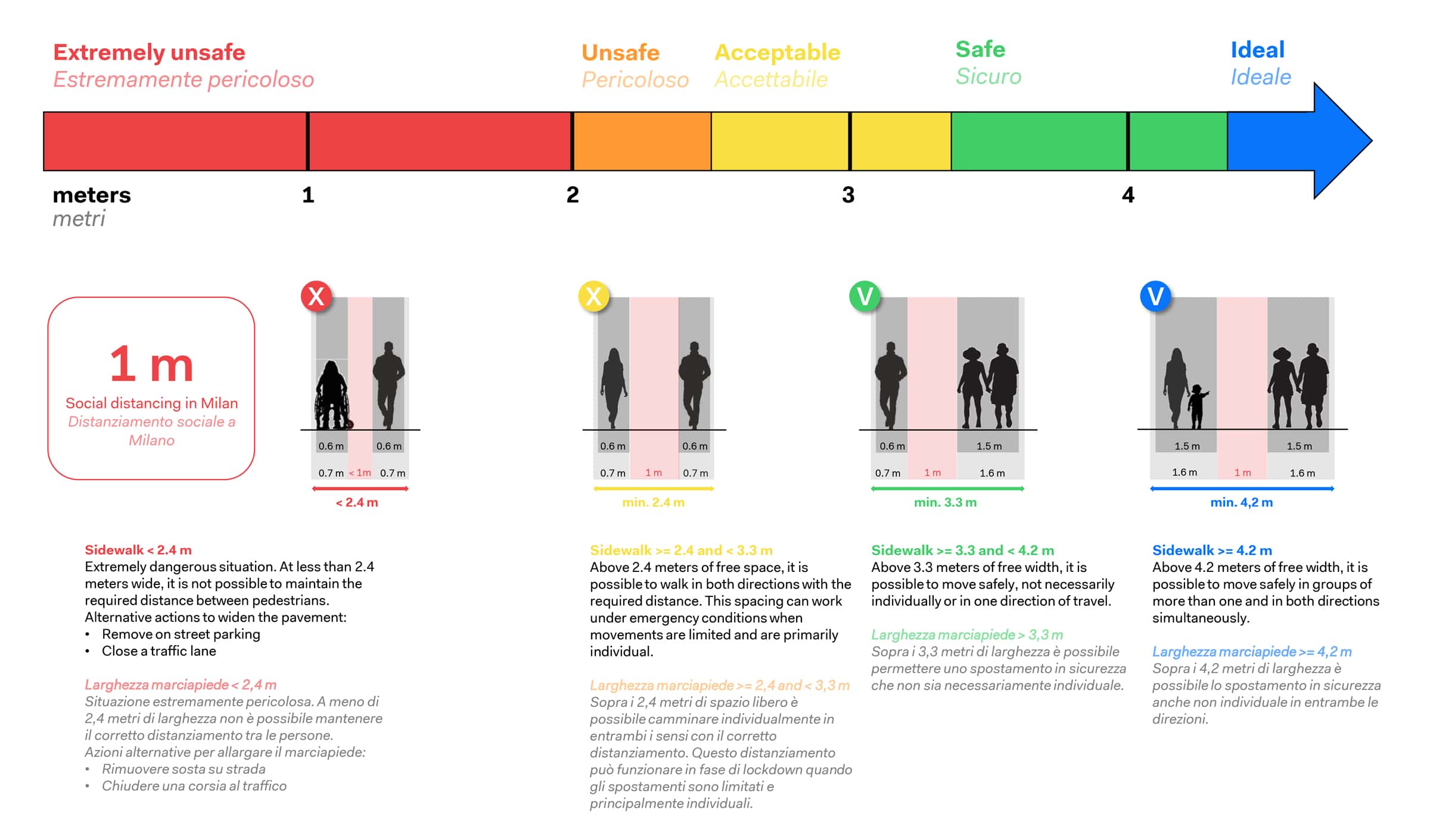
In Lombardy, the recommended interpersonal distance for contagion containment is 1 meter. Starting from this assumption, we considered the space occupied by each person (0.6 m + 0.2 m of comfort zone), applied the 1 meter spacing and assumed different sidewalk sections. In this way, we defined intervals to evaluate the level of suitability of sidewalks based on their width. It should also be noted that the measurements referred to at this stage imply the net walkable width of the pavement.
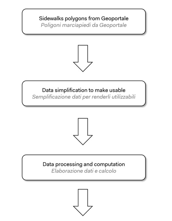
The making of the map
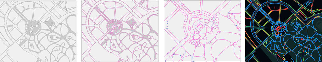
The map was built starting from the polygons of the pavements available as open source on the Geoportal of the Municipality of Milan. The data has therefore been simplified and cleaned up to make them usable. Starting from these polygons, the center line of each single sidewalk was obtained and the distance from the edges was calculated, i.e. between the edge of the roadway and the buildings. The data obtained therefore shows the width of each sidewalk, before deducting street furniture elements (street lamps, benches, …etc.). Once the new database was created, an interactive map was developed and published here.

Analysis
Sidewalks in Milan
By analysing the data from the East of Milan, we developed a clear idea of the existing situation of the sidewalks. Particular attention should be paid to the sidewalks in the “ideal situation” category as part of them are actually occupied by trees or by parked cars. On the other hand, 45% of the sidewalks do not meet the minimum requirements to guarantee adequate social distancing. In this sense, we propose some measures that could be implemented to expand the space available on the sidewalks:
- Remove on-street parking and parked cars on sidewalks
- Close, if even temporarily, a traffic lane
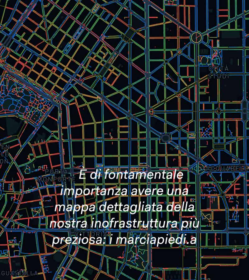
Below is shown a set of maps for each category of sidewalk width. This would help looking at clusters and identify areas where to intervene first.

Next steps
Today, Milan’s pedestrian infrastructure does not guarantee a homogeneous level of security with regards to current social distancing requirements necessary for the pandemic containment. It will therefore be necessary to encourage the implementation of wide-scale pedestrianization measures in several areas across the city, if even temporarily, in order to ensure safe pedestrian movement.
It is of fundamental importance to have access to a comprehensive mapping of our city’s pedestrian infrastructure. Undoubtedly, further detailing of the map is required to ensure reliability and up-to-dateness. It is also important to collaborate with city administrations to enable constant upgrading of the database.
It will be very interesting, as part of next steps, analyze this sidewalks’ database alongside other information regarding road hierarchy, vehicular traffic, public transport accessibility levels, demographic, etc.
This mapping tool will be essential for cities in decision-making processes as a means to facilitate the identification of intervention clusters, define priority areas and design adaptation measures most effectively.
![]() “The Milan Sidewalks Map research project is supported by the International Federation of Pedestrians, with the common objective to promote walkability and better response to combat the spread of the current and future pandemics”
“The Milan Sidewalks Map research project is supported by the International Federation of Pedestrians, with the common objective to promote walkability and better response to combat the spread of the current and future pandemics”
Il sovraffollamento e la densità abitativa sono per definizione due fattori cruciali dell’aumentare di rischio di pandemie. In un mondo globale iperconnesso, abitato da 7,5 miliardi di persone di cui il 55% concentrato in ambiti urbani (70% nel 2050) situazioni di emergenza sanitaria potranno essere un rischio sempre più frequente.
Il distanziamento sociale è la misura più efficace per prevenire e contenere la diffusione di pandemie. Le restrizioni che stiamo vivendo potrebbero quindi diventare parte delle nostre vite future e del modo in cui viviamo e pianifichiamo le nostre città.
Systematica ha declinato questa sfida applicando una metodologia su Milano, replicabile in qualsiasi centro urbano, per la mappatura ed il conseguente adattamento delle infrastrutture pedonali (marciapiedi) al fine di garantire il soddisfacimento dei requisiti di distanziamento sociale.
Il risultato preliminare delle analisi, che devono necessariamente essere verificare a valle di una raccolta dati più dettagliata, è che più del 40% dei marciapiedi di Milano non sono ad oggi adatti a garantire il necessario distanziamento sociale.
A tal fine, in linea con i principi e le iniziative recentemente promosse dal piano ‘strade aperte’ del Comune di Milano, una diffusa serie di interventi di riquaificazione dei nostri marciapiedi si rende assolutamente necessaria per garantire adeguati livelli di comfort e sicurezza.
Benefici per la municipalità
Mappare l’infrastruttura pedonale porta inevitabilmente molti vantaggi per molteplici attori. In primo luogo le amministrazioni otterranno una serie di benefici, tra cui:
- Implementare la capacità di analisi e pianificazione degli spazi pedonali
- Verificare l’idoneità delle infrastrutture pedonali nel rispetto delle regole di distanziamento sociale
- Prioritizzare e definire la tipologia di interventi in base alla situazione esistente
- Adattare in tempi rapidi le infrastrutture alle necessità emergenti
Una volta condivisa, la mappatura potrà essere un fondamentale strumento decisionale anche per pianificatori e cittadini.
Metodologia
Distanziamento sociale e marciapiedi
In Lombardia la distanza interpersonale raccomandata per il contenimento del contagio è di 1 metro. Partendo da questo presupposto abbiamo considerato lo spazio occupato da ogni persona (0.6 m + 0.2 m di comfort zone), applicato il metro di distanziamento e ipotizzato diverse sezioni. In questo modo abbiamo definito degli intervalli per valutare il livello di idoneità dell’infrastruttura pedonale in base alla sua larghezza. Da notare che in questa fase del ragionamento le misure si riferiscono alla larghezza calpestabile netta del marciapiede.
Come è stata realizzata la mappa
La mappa è stata costruita partendo dai poligoni dei marciapiedi disponibili opensource sul Geoportale del Comune di Milano. I dati sono stati quindi semplificati e ripuliti per renderli utilizzabili. Partendo da questi poligoni è stata ricavata la mezzeria di ogni singolo marciapiede e calcolata quindi la distanza dai bordi, ovvero dalla carreggiata e dagli edifici. Il dato ottenuto mostra quindi la larghezza di ogni marciapiede, al lordo degli elementi di arredo urbano (lampioni, panchine, …). Una volta creato il nuovo database la mappa è stata poi resa interattiva e pubblicata a questa pagina.
Analisi
Marciapiedi a Milano
Interrogando i dati della zona est di Milano ci siamo fatti un’idea della situazione esistenti dei marciapiedi. Particolare attenzione è da riservare ai marciapiedi con «situazione ideale» in quanto parte di essi sono in realtà occupati da alberature, ciclabili o da sosta su marciapiede. Il 45% di essi invece non soddisfa i requisiti minimi per garantire il corretto distanziamento sociale. In tal senso sono necessariamente da valutare alcune misure che potrebbero essere implementate per ampliare lo spazio disponibile sui marciapiedi:
- Rimuovere la sosta su strada/sui marciapiedi
- Chiudere, anche temporaneamente, una corsia al traffico
Sotto viene illustrato un set di mappe per ogni categoria di marciapiede per aiutare nell’identificazione di clusters e di aree prioritarie di intervento.
Prossime fasi
Ad oggi, l’infrastruttura pedonale di Milano non garantisce omogenee situazioni di sicurezza per quanto riguarda il mantenimento del corretto distanziamento sociale reso necessario per il contenimento della pandemia in corso. Sarà quindi necessario ed auspicabile incentivare e implementare misure di pedonalizzazione di diverse aree, anche in modo temporaneo, al fine di garantire movimenti pedonali in sicurezza.È di fondamentale importanza dotarsi di una mappatura comprensiva dell’infrastruttura pedonale nelle nostre città. Sicuramente un ulteriore dettaglio del lavoro è richiesto per assicurare la resa di un prodotto affidabile e aggiornato. È altresì importante lavorare al fianco delle amministrazioni per un costante aggiornamento del database.Sarà interessante e parte dei prossimi step interpolare il dato dei marciapiedi al resto della gerarchia stradale, ai flussi di traffico, livello servizio del trasporto pubblico, informazioni demografiche, etc.Tale mappatura si renderà essenziale nei processi decisionali delle amministrazioni in modo da facilitare l’identificazione di cluster di intervento, prioritizzare i provvedimenti e rendere più efficaci le misure di adattamento sul territorio.