
Security for women while walking
Advanced urban transport planning activities are shifting towards a focus on pedestrian mobility and walkability (Buhrmann et al., 2019), namely referring to how friendly the urban environment is for walking in terms of service availability, street connectivity, comfort of public spaces and road safety.
While traditional views of walkability tend to focus on the spatial dimension, the European Charter for Women Right in the City (1994) proves that female pedestrians experience the city differently than men, since women are more concerned with security issues related to aggression and harassment (Pollard & Wagnild, 2017; International Transport Forum, 2018).
Despite this has been recognized also by the New Urban Agenda – SDG 5 ‘Gender Inequalities’ (United Nations, 2017), there is still a lack of knowledge about the impact of security on walkability due to the difficulty in gathering data from public authorities about this topic. This requires developing assessment tools that consider suppressed, re-routed or delayed trips due to fear of violence, as a major inhibitor of mobility for women in public spaces especially at night time (Koskela, 1999).
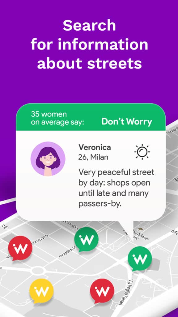
The route planner application Wher
In this framework, the route planner application ‘Wher’ is an effective tool for collecting geo-localized data regarding the women’s perceived level of security while walking in urban areas. Since 2019, the Wher app has been active in Turin, Milan, Catania and Naples (Italy), and soon it will be launched in the City of Barcelona (Catalonia, Spain).
Wher is an app in which a Community of Women help other women to move safely while walking. It consists of a map with safe ranking places, and it’s simple to understand thanks to traffic light colours. Users can add their own raking evaluation and also textual comments to enrich information about places. The navigator algorithm gives information about routes in which female users have to be more or less careful based on three time slots: day, evening, and night.
Wher is not just an app, Wher is also a vibrant Community called Wherriors, engaged in many activities in order to continue to map and refresh data, for example meetups, workshops, urban mapping, etc. During the Covid Lockdown they continue to map, even if they could not go outside.

The launching phase of the app required a selection of areas within the city to start data collection through the engagement of a large number of women users. In this regard, Systematica performed a GIS-based suitability analysis aimed at identifying the most relevant ‘Barrios’ or neighborhoods of Barcelona where to launch the app first.
GIS-based suitability analysis
A series of geo-localized open datasets have been collected, filtered and analyzed focusing on the characteristics of the 71 Barrios in terms of: land use (Copernicus Land Monitoring Service, 2012), parks and green areas (Copernicus Land Monitoring Service, 2012), points of interest (OpenStreetMap, 2020), demographic characteristics of the inhabitants (IDESCAT – the Statistical Institute of Catalonia, 2011) and public transports (OpenStreetMap, 2020).

Satellite data about urban fabric and land use have been analyzed to prioritize the Barrios localized nearby the city center of Barcelona (as more urbanized than peripheral ones).
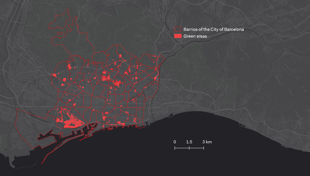
Satellite data about green areas have been analyzed to prioritize the Barrios characterized by the presence of parks and gardens, as negatively linked to the women’s perceived sense of security while walking, especially during the night time.
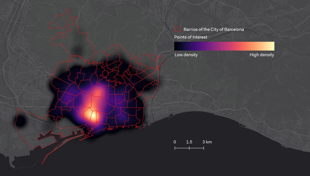
Data about points of interest have been analyzed to prioritize the Barrios characterized by specific target users of the app: youngest (bars, café, cinemas, nightclubs, pubs, restaurants and theatres), students (universities and colleges), tourists (camping, guesthouses, hostels, hotels).
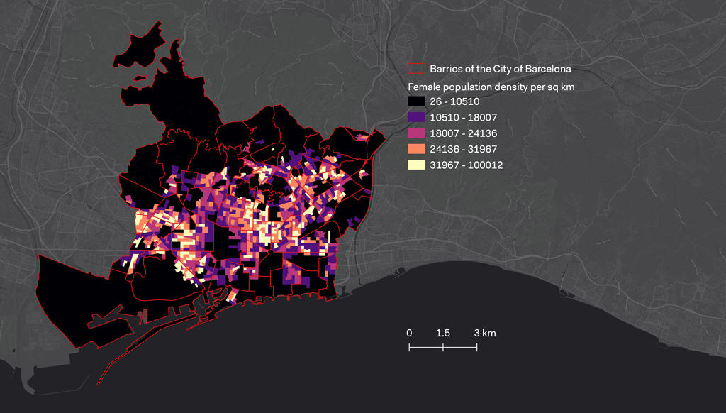
Data about the demographic characteristics of the inhabitants have been analyzed to prioritize the Barrios characterized by the presence of women residents, as target users of the app.
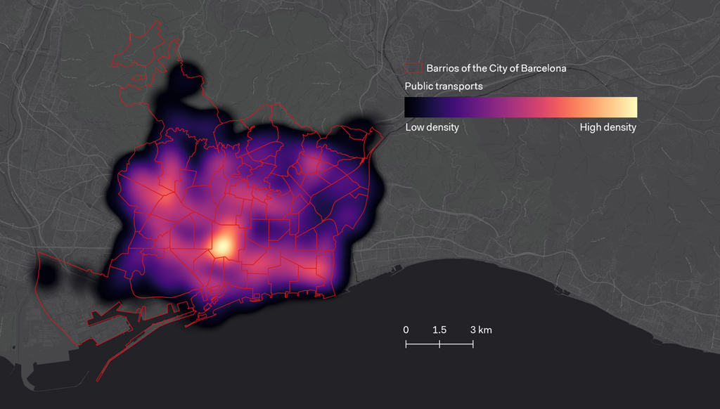
Data about public transport services have been analyzed to prioritize the Barrios characterized by the presence of metro and urban railway stations, as negatively linked to the women’s perceived sense of security while walking, especially during the night time.
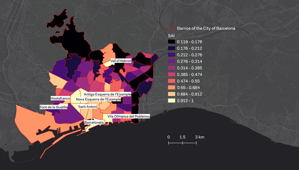
The relevant Barrios of Barcelona
Data were post-processed through: (i) density-based calculation considering the territory of each Barrio; (ii) normalization of values (z values in a range between 0 and 1); and (iii) weighted formula of normalized values to calculate the SAI_Barrio (Suitability Analysis Index):
(KUF*UF_Barrio) + (KGA*GA_Barrio) + (KPOIy*POIy_Barrio) + (KPOIs*POIs_Barrio)
+ (KPOIt*POIt_Barrio) + (KFP*FP_Barrio) + (KMRS*MRS_Barrio)
The constant parameters KUF – Urban Fabric (corresponding to 0.05), KGA – Green Areas (corresponding to 0.05), KPOIy – POI for youngest (corresponding to 0.25), KPOIs – POI for students (corresponding to 0.25), KPOIt – POI for tourists (corresponding to 0.25), KFP – Female Population (corresponding to 0.05) and KMRS – Metro and Railway Stations (corresponding to 0.1) were weighted to accentuate the impact of the density distribution of points of interest on SAI (∑ constant parameters = 1).
Quintile frequency distribution of results made possible the identification of the eight Barrios of Barcelona characterized by highest level of priority for the launch of the Wher app (SAI ≥ 0.912, corresponding to the 90th centile): Antiga Esquerra de l’Eixample, Barceloneta, Font de la Guatlla, Hostafrancs, Nova Esquerra de l’Eixample, Sant Antoni, Vall d’Hebr, Vila Olimpica del Poblenou. Results will be used to support the launching phase of the app in Barcelona.
The results of this research work have been presented at the 22nd International Walk21 Conference on Walking and Liveable Communities, 19-23 September, 2022, Dublin (Ireland).
Acknowledgments
We thank the team of Wher, for their fruitful collaboration and for sharing information for the calibration process of the Suitability Analysis Index.
References
Buhrmann, S., Wefering, F., Rupprecht, S. (2019). Guidelines for developing and implementing a sustainable urban mobility plan – 2nd edition. Rupprecht Consult-Forschung und Beratung GmbH.
European Commission (1994). European Charter for Women in the City. Moving towards a Gender-Conscious City.Commission of the European Union Equal Opportunities Unit.
International Transport Forum (2018). Women’s Safety and Security: A Public Transport Priority. OECD Publishing.
Koskela, H. (1999). ‘Gendered exclusions’: Women’s fear of violence and changing relations to space. Geografiska Annaler: Series B, Human Geography, 81(2), 111-124.
Pollard, T. M., & Wagnild, J. M. (2017). Gender differences in walking (for leisure, transport and in total) across adult life: a systematic review. BMC public health, 17(1), 1-11.
United Nations (2017). Habitat III Issue Papers. United Nations Conference on Housing and Sustainable Urban Development, New York.