
Sustainable mobility and walkability
The rising demand for transport services and infrastructure linked to urbanization (United Nations, 2014) requires an institutional process to effectively design and plan future cities. This process should aim to achieve environment-related goals at local and national levels, and ultimately to improve quality of life (Vandecasteele et al., 2019). Encouraging the shift towards sustainable mobility strategies based on public transport and active modes of travel (i.e. Sustainable Urban Mobility Plan) is one of the main goals of European cities (Buhrmann et al., 2019), since most European cities are facing problems of increasing traffic congestion, air pollution, as well as roadway safety concerns.
To address this goal, advanced urban planning activities are shifting towards a focus on walkability and improving the infrastructure to support walkability. Planning efforts include the development of strategies and design elements which enhance the accessibility, comfort and safety of the urban setting for walking, while also considering the needs of vulnerable road users (e.g. pedestrianization of urban areas, barrier-free streets, public spaces for outdoor activities). According to the General Theory of Walkability (Speck, 2013), the essential elements for evaluating the level of walkability of urban environments. These include the following:
• Presence of services within a walkable distance;
• Level of comfort and safety experienced by pedestrians;
• Attractiveness of the urban areas in terms of architectural design and social context.
As highlighted by the 2030 Agenda for Sustainable Development Goals (SDGs) adopted by the United Nations in 2016, there are several targets directly linked with making walking a primary travel mode beyond a first -and-last-mile solution to connect to public transport. Walking is recognized as a catalyst, a fundamental driver of sustainable urban development as part of a wider planning approach which entrusts the role of leading actor to active mobility, as an intrinsic dimension to the quality of life experienced in cities. Walking ensures direct access to any urban opportunity, and accessibility constitutes the qualifying and transversal element with respect to all other urban disciplines.
If in the past, distance represented the element capable to shape the physical structure of cities, today it’s time, the fourth dimension by its intangible nature. Time transforms the city’s functional form and guarantees the correct use of urban functions beyond efficiency and speed.
Walking, therefore, ensures social participation provided by a system of public spaces, primarily streets, and squares and parks. This represents the most strategic asset of the urban built environment, the most long-standing elements of the urban fabric that remains over time and shapes the city.
Resilient infrastructures for pedestrian mobility
Streets are called to deal with patterns and variables that are not all predictable to date and, in this sense, they must act as flexible and resilient infrastructural elements capable of accommodating new forms of transport and adapt to future mobility trends.
In particular, the resilience and flexible use of the public space has become a more urgent necessity as a result of the COVID-19 pandemic, which will definitely generate a new mobility morphology due to different travel behaviors of the post pandemic scenario, among which an expected reduction of the overall “mobility consumption” (space) as well as new urban rhythms (time). This crisis opens opportunities for decades to come to reshape and redesign our cities.
The idea of safe, generous, and accessible common space is fundamental to public life. We need a greater amount of public space, which is more spacious, more articulated, more polysemic and multifunctional; a hybrid space, made up of several components, that is flexible for different uses.
Experiments and concrete interventions are being launched all over the world. As an example, the Open Streets plan of the Municipality of Milan[1] (2020) provides an initial framework for promoting pedestrian mobility in order to reduce risk of contagion associated with high contact and crowding in mass transit facilities, but also to reduce the use of private transport modes. In this regard, the European Commission (2020) has recently provided guidelines for short-term urban mobility and transport planning interventions to face the critical situation due to the COVID-19 pandemic. Among the principles included in the document, the section ‘Active Mobility’ has a specific focus on walkability: “Many European cities are taking steps to make active mobility (e.g. walking and cycling) a safe and more attractive mobility option during the COVID-19 outbreak. Urban areas could consider temporary enlargements of pavements and increased space on the road for active mobility options to facilitate the needs of the population to move in a safe and efficient way, while reducing speed limits of vehicles in increased active mobility areas” (European Commission, 2020, p.15).
This includes short-term interventions on road network and public transport infrastructures (i.e. temporary enlargement of sidewalk infrastructures, social distances and queue management in transit infrastructure), to guarantee the possibility to access public transport, services, retails and goods within a comfortable walkable distance from home.
Actions that redefine the relationship among different mobility systems are needed, imagining new ways to distribute the space on the road and also to radically rethink the uses of urban spaces. From the point of view of urban planning, this is a topic that is both critical and exciting at the same time: a decisive redefinition of limits and spaces is not always possible and not everywhere, although certainly this moment of rethinking represents a great opportunity to give new priorities and imagine more virtuous initiatives and new balances.
Computer-based models for pedestrian dynamics simulation
In just a few months both nation-wide lockdown and post-lockdown phases have drastically changed citizens’ behaviors and mobility patterns in cities, neighborhoods, and streets. As such, it’s necessary to investigate the unprecedented changes and long-term effects of disruption on urban mobility. In this framework, Urban Informatics (Foth et al., 2011) provides an innovative and multi-disciplinary walkability assessment tools and metrics for supporting the activity of mobility and transport planners in an efficient and effective manner within an evidenced-based approach.
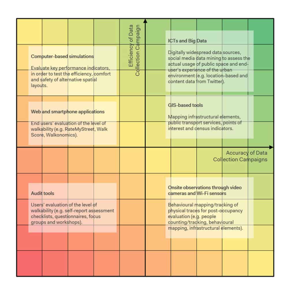
In this framework, computer-based systems for the simulation of pedestrian dynamics provide optimized solutions for supporting the activity of transport planners and decision makers in the design of transport infrastructures. This is based on the possibility to evaluate key performance indicators (e.g. travel time, density condition, waiting time), to test the efficiency, comfort and safety of alternative spatial layouts and traffic management conditions (i.e. what-if scenarios) in a predictive and explanatory scheme.
Static assessment metrics already allowed to define the negative effects of disruption related to COVID-19 pandemic crisis on mass transit/gathering infrastructure capacity. The current work is aimed at applying simulation models to investigate the phenomenon in dynamic conditions focusing on pedestrian mobility. In particular, we applied a descriptive set of metrics and parameters for representing the impact of social distancing into the Social Force Model of the pedestrian simulation platform PTV Viswalk (Kretz et al., 2018).
We focused on calibrating the dynamic regulation of interpersonal distances among pedestrians (i.e. social isotropic parameters related to repulsive force), to avoid conditions of inappropriate proximity and spatial restriction due to high density situations.
The proposed calibration phase allowed us to compare simulation results between the Social Force Model and the proposed Social Distancing Model. This was based on the execution of a simulation campaign focused on: (i) pedestrian counter flow situation in a corridor-like scenario (3-meter width, representing the average width of sidewalks in urban areas); (ii) characterized by Level of Service B (corresponding to irregular flow in condition low-medium density).
The proposed discretization of the simulated environment (each cell is of 0.2×0.2 meter) is focused on the recommended space for guaranteeing social distancing in dynamic situations (1 meter) and allowed to calculate the level of density in the simulated scenario, identifying those cells with a density higher than 1 pp/sqm for each second of the simulation (300 seconds in total). Preliminary simulation results showed that (i) pedestrian dynamics driven by the Social Force model (ordinary conditions) were characterized by temporary/local situations of high density and queueing due to the limited capability of the infrastructure to accommodate pedestrian flows, and that (ii) pedestrian dynamics driven by the proposed Social Distancing Model (tested condition) were characterized by continuous detouring maneuvers and speed adjustment to avoid proximity with other agents. For this reason, the pedestrian model was updated through the possibility to segregate pedestrian flows considering their direction of movements (i.e. agents’ preference to maintain the right side of the pathway while walking). The implemented solution allowed smooth pedestrian circulation dynamics and to achieve more stable results while introducing social distancing behavioural metrics.
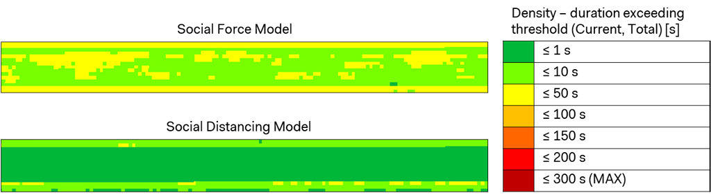
The proposed approach represents an innovative contribution for the estimation of the impact of social distancing on pedestrian dynamics, comparing the traditional approaches devoted to the mere estimation of flow rate (Highway Capacity Manual, 2010) and Level of Service (Fruin, 1971). This is linked to the possibility to evaluate the need to provide short-term urban mobility and transport planning interventions (e.g. temporary enlargement of sidewalk infrastructures, queue management in transit infrastructure), within an-evidence based approach. Given the current level of maturity and expressiveness of commercial simulation platforms in modeling social distancing dynamics among pedestrian flows, the proposed approach represents a preliminary test based on an experimental calibration phase.
Future work will be focused on:
• Comparing results through different commercial simulation platforms, once calibrated and validated against real data;
• Simulating pedestrian dynamics in more complex spatial layouts;
• Introducing the notion of shared space among group members (e.g. family, friends);
• Executing people counting activities and video-recorded observations of behavioral patterns related to social distancing to better inform and calibrate the simulation model against real scenario;
• Evaluating the plausibility of the model against the so-called fundamental diagram (Seyfried et al., 2005), in which the relationship between the variation on the pedestrian flow with respect to the increasing of the level of density is represented.
Acknowledgments
Systematica would like to thank the PTV Group, for sharing information about the calibration process of the pedestrian simulation software PTV Viswalk.
References
Buhrmann, S., Wefering, F., Rupprecht, S. (2019). Guidelines for Developing and implementing a sustainable urban mobility plan – 2nd edition. Rupprecht Consult-Forschung und Beratung GmbH.
European Commission (2020). COVID-19: Guidelines on the progressive restoration of transport services and connectivity, European Commission, Brussels.
Foth, M., Choi, J.H.j., Satchell, C. (2011). Urban informatics. In: Proceedings of the ACM 2011 conference on Computer supported cooperative work, pp. 1–8.
Fruin, J.J. (1971). Pedestrian Planning and Design, Metropolitan Association of Urban Designers and Environmental Planners, New York.
Highway Capacity Manual (2010). Highway Capacity Manual, Transportation Research Board, National Research Council, Washington, DC, 2010.
Kretz, T., Lohmiller, J., & Sukennik, P. (2018). Some indications on how to calibrate the social force model of pedestrian dynamics. Transportation research record, 2672(20), 228-238.
Seyfried, A., Steffen, B., Klingsch, W., & Boltes, M. (2005). The fundamental diagram of pedestrian movement revisited. Journal of Statistical Mechanics: Theory and Experiment, 2005(10), P10002.
Speck, J. (2013). Walkable city: How downtown can save America, one step at a time. Macmillan, New York City.
United Nations (2014). World urbanization prospects, the 2011 revision. Department of Economic and Social Affairs, Population Division, United Nations Secretariat, New York.
United Nation (2016). Transforming our world: The 2030 agenda for sustainable development. United Nations Secretariat, New York.
Vandecasteele I., Baranzelli C., Siragusa A., Aurambout J.P. (2019). The Future of Cities – Opportunities, challenges and the way forward. Publications Office of the European Union.